YouthMappers: dalle università i mappatori OpenStreetMap di domani
Le wikigite del fine settimana: scatto finale in Basilicata, Lazio e Lombardia!
27 Settembre 2018
Le storie di Wiki Loves Monuments: fotografare per condividere un’esperienza
8 Ottobre 2018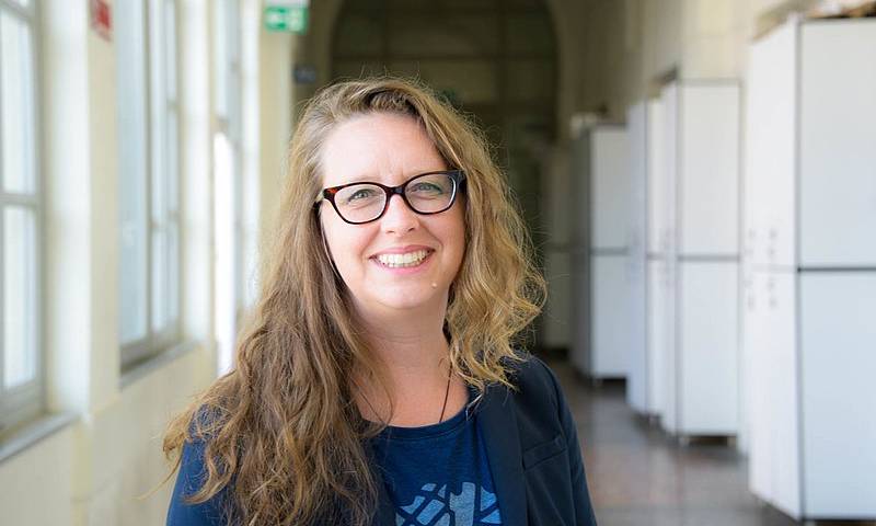
“We don’t build maps, we build mappers”: questo è il motto degli YouthMappers, il network che unisce studenti e docenti universitari di tutto il mondo con l’obiettivo di promuovere la conoscenza di OpenStreetMap, formare nuovi contributori alla mappa libera e metterli in connessione per trovare soluzioni innovative a problemi concreti grazie a OSM.
In occasione di State of the Map 2018 Milano, abbiamo incontrato Patricia Solis, Direttrice e fondatrice del progetto, che ci ha spiegato com’è nata la rete di YM e perché è importante.
Com’è nato il progetto YouthMappers?
YouthMappers è nato nel 2015 quando, in occasione del terremoto che ha colpito il Nepal, diverse organizzazioni in tutto il mondo si sono attivate per supportare le operazioni di soccorso, anche attraverso la mappatura da remoto su OpenStreetMap.
Alcune università – tra cui la Texas Tech University, dove ero ricercatrice, la George Washington University e la West Virginia University – avevano già dal 2013 iniziato a collaborare con Croce Rossa americana per mappare la zona di Kathmandu, altamente esposta a catastrofi naturali e caratterizzata da edifici ad elevato rischio di crollo.
L’emergenza di aprile 2015 ha creato le condizioni per fare un passo in avanti: osservando la risposta rapida ed efficace dei mappatori delle università di fronte a questa tragedia, il GeoCenter di USAID ha chiamato a raccolta i diversi atenei e messo a disposizione i fondi per creare una rete capace non solo di attivarsi in situazioni di emergenza ma anche di svolgere un’attività continuativa di mappatura su OpenStreetMap e di formazione agli studenti.
La decisione di USAID di supportare il network non giunge “dal nulla”, ma rappresenta il punto di arrivo di una collaborazione decennale tra gli atenei e l’agenzia sul fronte della formazione e della raccolta di dati geospaziali.
YouthMappers rappresenta il tentativo di creare “una comunità nella comunità”, mettendo in connessione docenti e studenti che desiderano avvicinarsi o sono già attivi in OpenStreetMap.
Ad oggi sono ben 120 i capitoli YouthMappers in tutto il mondo (i primi in Europa sono stati i nostri PoliMappers a Milano!): come siete arrivati a questo stupefacente risultato?
A mio avviso il primo punto di forza di YM sta nell’aver individuato negli studenti il motore propulsivo. Sono i ragazzi che guidano il processo, decidono di fondare un capitolo e sono poi chiamati a dirigerlo. I docenti sono chiamati invece a ricoprire il ruolo di faculty mentor, per avere un riconoscimento formale all’interno dell’università.
YouthMappers ha inoltre il pregio di aggregare persone che si trovano in un momento “speciale” della loro vita, quello in cui ci si dedica alla propria formazione: gli studenti universitari hanno tanto tempo, tante idee e sono estremamente ricettivi.
Da ultimo, ciò che ha davvero funzionato e consentito di coinvolgere tantissime persone è stato far capire che OpenStreetMap non serve “solo” a registrare dati geografici su strade o edifici ma è una comunità di persone che si mobilita per rispondere a esigenze reali. Le campagne di mappatura lanciate da YouthMappers in collaborazione con partner come USAID o lo Humanitarian OpenStreetMap Team, un altro dei partner del progetto, hanno sempre un obiettivo concreto.
A tuo avviso, che cosa apprende uno studente attraverso YouthMappers?
Credo sia un’esperienza che cambia il modo in cui i giovani vedono il mondo. Una volta una studentessa mi ha detto che viaggiando attraverso la mappa libera si è davvero sentita una “cittadina globale”. Un altro studente, che non aveva mai avuto l’occasione di lasciare gli Stati Uniti, partecipando a una campagna di mappatura in Nord Uganda ha potuto scoprire il territorio quasi come se davvero avesse visitato il Paese.
Ma non solo! Attraverso la rete ha potuto conoscere e raccogliere informazioni di prima mano dagli studenti affiliati al capitolo ugandese: si è creata una connessione che va al di là del supporto tecnologico.
Questo è il vero valore aggiunto: non si tratta solo di arricchire la mappa, ma anche di entrare in contatto con le persone.
D’altra parte, esiste un vantaggio anche per le istituzioni coinvolte: alcune università grazie a YM hanno aperto nuove linee di ricerca, altre attraverso il lavoro di mappatura degli studenti hanno avuto l’opportunità di farsi conoscere a livello globale e accrescere la propria rilevanza in ambito accademico.
Quali sono le maggiori sfide di YouthMappers per il futuro?
Uno dei temi chiave da sempre è la qualità dei dati, che vorremmo migliorare sempre di più. Mi piacerebbe che tutto ciò che viene registrato su OpenStreetMap con il tag YouthMappers fosse automaticamente riconosciuto dagli utenti come “corretto e verificato”. Siamo sulla buona strada, ma c’è sempre spazio per migliorare!
L’altra grande sfida è quella del divario di genere, una realtà per la comunità OpenStreetMap. Un progetto come YouthMappers può fare molto in questo senso, perché agisce in un ambiente come l’università, in cui la percentuale di studentesse è piuttosto alta.
Molti dei capitoli YouthMappers sono composti al 30-40% da studentesse e in Bangladesh uno è addirittura composto al 100% da ragazze; anche lo stesso board di YouthMappers è composto prevalentemente da donne!
Merito di questa grande partecipazione sono anche le tematiche su cui la rete si è attivata: ad esempio, per la Giornata mondiale della Donna abbiamo lanciato la campagna Let Girls Map o, ancora, abbiamo contribuito a mappare da remoto le zone interessate dalla mutilazioni genitali femminili o dove le donne sono oggetto di violenza: ad esempio in Tanzania, in collaborazione con il Tanzania Development Trust. Diciamo che non è solo la tecnologia open source la nostra forza, ma la capacità di connettere le persone.
Da ultimo, credo sia importante sottolineare il ruolo che OpenStreetMap e YouthMappers possono svolgere nei Paesi in via di sviluppo come veicolo di crescita e autodeterminazione. I capitoli YouthMappers attivi in Nepal, Uganda o in Ghana ad esempio hanno completamente ribaltato lo schema per cui sono le nazioni “del primo mondo” a fungere da traino, promuovendo progetti innovativi che sono studiati con interesse da tutti gli altri capitoli in Europa e negli Stati Uniti.
Non ci resta che fare a Patricia un grande in bocca al lupo, e se desiderate lanciare il vostro capitolo YouthMappers, trovate qui tutte le informazioni per farlo!
Nota:
Un ringraziamento speciale da parte di Patricia va al Fulbright Specialists Program e alla Prof.ssa Maria Brovelli, che hanno reso possibile la sua partecipazione all’edizione 2018 di State of them Map. Qui i riferimenti di Patricia per ogni quesito:
Patricia Solis, PhD
CoFounder and Director, YouthMappers
Executive Director, Knowledge Exchange for Resilience
Arizona State University
www.youthmappers.org
Nell’immagine: Patricia Solis a State of the Map 2018 Milano. Di Francesco Giunta, CC BY-SA 4.0, via Wikimedia Commons
English Translation
“We don’t build maps, we build mappers”, this is the motto for the international network YouthMappers, a community gathering students and professors from all over the world. The aims of the project are to increase the awareness about OpenStreetMap and train new contributors for the open map, as well as to connect young people around the world to make a difference through mapping.
On the occasion of State of the Map 2018 Milano, we met Patricia Solis, CoFounder and Director of YouthMappers, who explained to us how the network started and developed.
Hi Patricia, nice to meet you! We want to know everything about YouthMappers: how was the project born?
YouthMappers was born in 2015 when, on the unhappy occasion of the earthquake in Nepal, many humanitarian organisations all over the world took action to support rescue operations, also using OpenStreetMap remote mapping.
Some universities, including the Texas Tech University – where I was working as a researcher – the George Washington University and the West Virginia University, were already working with the American Red Cross since 2013 in order to map the area around Kathmandu which is highly exposed to natural disasters and where many vulnerable buildings are at a high risk of collapse.
The emergency in April 2015 created the conditions to take a step forward: after noticing the rapid and efficient reaction of the OSM mappers from different universities before the tragedy, the USAID GeoCenter decided to engage the universities and provided funds to create a stable network, ready to take action in emergency situations but also able to conduct ongoing mapping activities on OpenStreetMap as well as design trainings for students. The support for this new idea built upon more than a decade of collaboration around geospatial analysis and capacity building that our co-founders had been doing with USAID.
YouthMappers represents the attempt to create “a community within the community” and connect university students and their faculty mentors willing to contribute to OpenStreetMap in the academic world.
Today there are 120 YouthMappers chapters all over the world (the first in Europe were PoliMappers in Milan!): how did you achieve this incredible result?
In my opinion, the main driving value of YouthMappers are the students, who represent the energy and the spirit of YouthMappers. Students take the lead, they decide whether to start a new chapter and they have to run it. Professors participate as faculty mentors to let students have a formal recognition and an official longer-term connection with the University.
Also, YouthMappers manages to gather people in a “special” moment of their life, when they are dedicating themself to education: university students have time at their disposal, ideas and they are extremely curious and responsive.
Beyond that, what really worked out with YouthMappers was making people understand that OpenStreetMap is not “only” registering geodata or tracking streets and buildings, but it’s a community of real people who take action to respond to specific and real needs.
Mapping campaigns launched by YouthMappers in collaboration with partners such as USAID and the Humanitarian OpenStreetMap Team are always related to specific and concrete objectives.
In your opinion, what can a student learn through Youth Mappers?
I think YouthMappers changes the way youth look at the world. Once, a student told me that when she travels through the open map, she truly feels like a global citizen. Another student never had the chance to leave his state, but when he took part in a mapping campaign aimed at collecting geodata in Northern Uganda, he was able to discover the region even without actually being there. Through the network he also managed to interact with the Ugandese student members of the local chapter to gather first-hand information: a human connection, that went beyond the technological support. This is the true value of YouthMappers as a project: it is not only about filling the map with data, but also about connecting people.
Also Universities can take advantage of this project: thanks to YouthMappers, some departments launched new lines of research or new curriculum, while others had the opportunity to achieve relevant academic recognition at global levels thanks to the mapping activities led by their students.
What will be the major challenges for YouthMappers in the future?
One of the main topics has always been the data quality, that we are always trying to improve. I would like everything which is registered on OpenStreetMap with the tag “YouthMappers” to be automatically recognized by users as “good and verified” data. This is a long-term goal, but we are working on it!
The other great challenge is the gender gap, which is still a problem within the OpenStreetMap community. A project like YouthMappers can do a great deal in this respect because it is implemented in universities, where women are often very well represented.
About a third of YouthMappers chapters are over 50% female and we also have one all female chapter in Bangladesh. Also the YouthMappers leadership is made up of several women!
I also think that the humanitarian activities promoted by the YouthMappers network helps attract women, and students in general. This worked for the launch of the Let Girls Map campaign on International Women’s Day and the mapping of certain areas of the world where women are subjected to genital mutilation and other forms of violence, such as when we teamed up with the Tanzanian Development Trust. We can say that open technology is not our only asset, we also have the ability to connect people with this technology.
Finally, I think that OpenStreetMap and YouthMappers can work as a leverage for countries in process of development as a vehicle of empowerment in a way that goes beyond traditional postcolonial concepts assuming that “Western countries are the experts”. For example, YouthMappers chapters in Nepal, Uganda and Ghana, which are considered as “developing countries”, have been working on innovative projects that are followed with interest by chapters worldwide, including leading new ideas for peers in Europe and the USA.
So for now, thank you and good luck Patricia! And for you, readers, if you want to launch your YouthMappers chapter, you can find here all the information on how to do it!
Note:
A special acknowledgement from Patricia goes the Fulbright Specialists Program, and her host Maria Brovelli, who made possible her participation to SOTM 2018.
Here below Patricia’s contact details for any inquiries:
Patricia Solis, PhD
CoFounder and Director, YouthMappers
Executive Director, Knowledge Exchange for Resilience
Arizona State University
www.youthmappers.org
Photo: Patricia Solis at State of the Map 2018 Milan. Taken by Francesco Giunta, CC BY-SA 4.0, via Wikimedia Commons
News correlate